
L04 · Carlyle, Illinois
GIS Mapping & Geospatial Services
GIS work takes scattered records, measurements, and field observations and turns them into one accurate, usable map that people can actually search, share, and update.
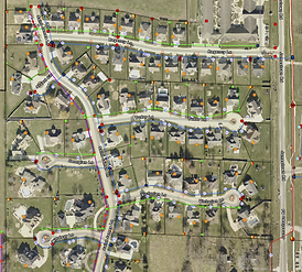
Mapping and database development
We build GIS maps and databases that organize property, infrastructure, and project information into layers that make sense for how the data will be used. That includes GIS mapping and database development, property mapping, aerial and imagery mapping, data conversion, and custom GIS solutions shaped to a specific workflow.
Asset and utility mapping
Knowing where infrastructure sits, and having that record in a form everyone can reach, is often the difference between a routine repair and an excavation surprise. Asset and utility mapping, field data collection, and GIS hosting services give an organization a maintained record instead of a stack of disconnected drawings.
Grounded in survey accuracy
GIS built from unverified data is a map of guesses. Our geospatial work is produced by a licensed surveyor from our Carlyle, Illinois office, using Trimble GNSS equipment and Esri ArcGIS so the features on the map correspond to measured positions on the ground, across Clinton County and the wider Southern and Central Illinois region.
- Data Model
- Esri geodatabase
- Layers
- Parcels, utilities, elevation
- Equipment
- Trimble R12i, Esri ArcGIS
- Deliverable
- Geodatabase, web map, feature services
Based in Carlyle, Illinois
LAH Surveying & Geospatial works from Carlyle, Illinois, serving Breese, Clinton County, and the surrounding communities throughout Southern and Central Illinois. Dustin Stine, PLS, is licensed to perform survey and geospatial work statewide in Illinois.
Common Questions
What kinds of deliverables are possible?
Depending on the project, deliverables may include digital GIS maps, interactive maps, GIS databases, shapefiles, geodatabases, CAD files, asset inventories, georeferenced imagery, and customized mapping products.
Is GIS work separate from a survey?
It can stand alone, but it benefits from survey control. Combining geospatial work with field surveying is what keeps map features tied to real, measured ground positions.
Do you serve clients outside Clinton County?
Yes. We are based in Carlyle, Illinois, and serve clients throughout Southern and Central Illinois, with survey licensing statewide in Illinois.
Request Geospatial Services
Send your site address and project details through the survey request form, or call to talk through the work directly. Requests are reviewed by a licensed surveyor.