
L01 · Carlyle, Illinois
Topographic Surveys in Carlyle, Illinois
A topographic survey maps what is already on a site, the ground shape and the features sitting on it, so the people designing and building there are working from measured conditions instead of assumptions.
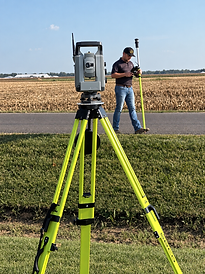
What the survey captures
Field measurements record existing elevations across the parcel along with the visible features that affect how it can be used, including structures, pavement, utilities and improvements, tree lines, and other site detail. Contours are drawn at a tight enough interval to support real design decisions.
Who uses the results
Engineers sizing drainage, architects setting finished floor elevations, contractors estimating earthwork, and property owners planning an addition or site improvement all rely on the same base information. Having it surveyed once, accurately, keeps the whole project team working from one shared picture of the site.
Grading, drainage, and site development
Flat-to-rolling ground in Clinton County and the surrounding region often drains in ways that are not obvious from standing on the lot. A topographic survey makes those patterns measurable before a slab, driveway, or retention plan is committed to. Projects across Carlyle, Breese, and Southern and Central Illinois are surveyed with this in mind.
- Standard
- ALTA/NSPS 2021
- Contour Interval
- 0.5ft – 1ft
- Equipment
- Trimble S7, R12i GNSS rovers
- Deliverable
- Graded topo map, CAD file, DTM
Based in Carlyle, Illinois
LAH Surveying & Geospatial works from Carlyle, Illinois, serving Breese, Clinton County, and the surrounding communities throughout Southern and Central Illinois. Dustin Stine, PLS, is licensed to perform survey and geospatial work statewide in Illinois.
Common Questions
What is the difference between a boundary survey and a topographic survey?
A boundary survey establishes where the property lines are. A topographic survey maps the elevations and features within the property. Many projects need both, and they are often completed together.
Can this be used for an addition or a new build?
Yes. Topographic surveys are commonly used for new construction, additions, site development, grading and drainage work, and engineering or architectural design.
Do you work with my engineer or architect?
We do. The survey is prepared to give your project team the site information they need, and we are happy to coordinate on format and what the design requires.
Request Topographic Surveys
Send your site address and project details through the survey request form, or call to talk through the work directly. Requests are reviewed by a licensed surveyor.